Probabilistic Methods

Focus on probabilistic analysis of sparse Lagrangian datasets instead of individual trajectory.

From Lagrangian datasets of surface buoys (such as the GDP and CARTHE drifters) or subsurface floats (such as RAFOS/SOFAR and Argos floats), probabilistic methods allows to combine the information contains in thousands of trajectories into a tool called the Transfer Operator.

The discrete version of this operator is the transition matrix P and each Pij coefficient represents the probability of moving from bin i to bin j during the fixed transition time T.

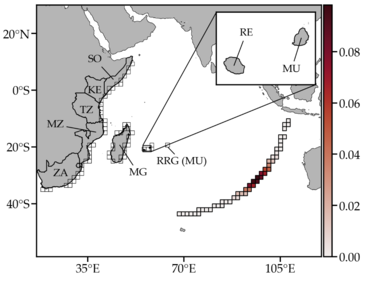
From an initial spatial distribution of a density f(x) (such as a passive tracer), a left multiplication (ft = f0P) by the transition matrix pushes forward the inital density to obtain its distribution at a latter time. See below the applications to the Pulley-Ridge reefs.

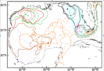
From the eigenspectrum (eigenvalues and eigenvectors) of the same transition matrix P, it is possible to extract the encoded region where trajectories converge and their respective basins of attraction. The right eigenvectors of P are the basins of attraction while the left eigenvectors are the attractors (or the almost-invariant region).

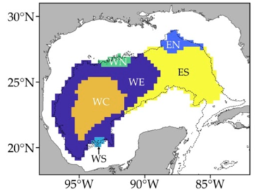
By combining almost-invariant region, it is possible to construct what we defined as a Lagrangian geography, fromed of weakly dynamically interacting provinces, which constrain the connectivity between distant locations within the Gulf of Mexico.

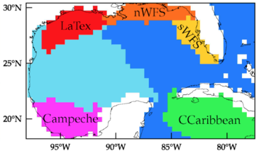
The surface Lagrangian geography highlights a main east–west division of the Gulf of Mexico and 5 coastal subdivisions,

Lagrangian geography surface

while the deep Lagrangian geography shows a similar east–west division with 4 subdivisions, including the WC region that contains a cyclone.

Deep Lagrangian geography

Connectivity of Pulley Ridge With Remote Locations as Inferred From Satellite‐Tracked Drifter Trajectories

The surface pathways uncovered by the drifter trajectories constitute a first‐order approximation for larval motion for species that have buoyant egg masses, such as lionfish (Morris et al., 2009), and broadcast spawners for which a fraction of larvae may reach the surface, such as the great star corals (Holstein et al., 2015; Wellington & Fittt, 2003). 

With this in mind,in Olascoaga et al. 2018, we used the transition matrix constructed from trajectories of surface drifters to approximate the dispersion of larvae from different reefs in the Gulf of Mexico and the Caribbean Sea. The main goal was to identify the connectivity of Pulley Ridge, a mesophotic coral reef system with other locations in the Gulf of Mexico and adjacent areas.  

Connectivity of GoM reefs

The study further suggests that the reefs in the Caribbean Sea, the Dry Tortugas, the western Florida Keys, and the West Florida Shelf can act as sources for Pulley Ridge, indicating the importance of Pulley Ridge as a central refugium for species in the Gulf of Mexico.

Markov-chain-inspired search for MH370

Markov-chain models are constructed for the probabilistic description of the drift of marine debris from Malaysian Airlines flight MH370. En route from Kuala Lumpur to Beijing, MH370 mysteriously disappeared in the southeastern Indian Ocean on 8 March 2014, somewhere along the arc of the 7th ping ring around the Inmarsat-3F1 satellite position when the airplane lost contact.

The models are obtained by discretizing the motion of undrogued satellite-tracked surface drifting buoys from the global historical data bank. A spectral analysis, Bayesian estimation, and the computation of most probable paths between the Inmarsat arc and confirmed airplane debris beaching sites are shown to constrain the crash site, near 25°S on the Inmarsat arc.

Bayesian Analysis of MH370